An intensifying cyclone is making a beeline for Auckland and Northland this weekend, with the worst of the storm to strike on Sunday.
More than half a dozen watches and warnings are in place for the North Island and top of the South Island through midweek, while a separate cyclone is set to “directly hit” Northland and Auckland later this week, becoming widespread by Sunday.
At lunchtime Tuesday it was upgraded to a category 3 tropical cyclone with winds around the centre in excess of 150km/h.
Brunt of storm to hit Sunday
Vaianu is about 600km northwest of Nadi in Fiji, with Metservice having warned it’s set to make direct impact with the top of the North Island this weekend.
Forecasters say it is too early to lock in a definite path for Vaianu, other than it is currently tracking to directly hit Northland and Auckland, with the brunt of the weather forecast for Sunday.
The cyclone is expected to deliver strong winds, large swells and heavy rain.
MetService reported its forecast to move southeastwards across the North Island towards East Cape by midnight Sunday, bringing harsh rain to much of the north and strong winds to Manawatū and Tararua districts.
“For the North Island from the Tararua District and Manawatū northwards, there is moderate confidence winds will rise to severe gale in exposed places. Winds are initially forecast to blow from the east to southeast and are followed by southwesterlies as Cyclone Vaianu moves southwards.”
“In addition, a front is expected to move northwards over southern New Zealand, while weakening.”
Whangarei District Council general manager community services group Victoria Harwood told the Herald they were closely monitoring the situation and planning for any possible weather impacts from Vaianu.
“Our roading contractors have been out clearing drains and debris in preparation for further heavy rain and our council civil defence team is ready to mobilise should it be required.
“People should continue to follow the latest weather updates from MetService and the advice of Northland Civil Defence.”
Harwood has advised residents can prepare by checking and clearing drains, gutters and downpipes as well as securing any outdoor furniture and trampolines that may fly around in wind.
“People can also report any blocked council drains to us by phoning us on 0800 932 463 and we will send someone to unblock them.”
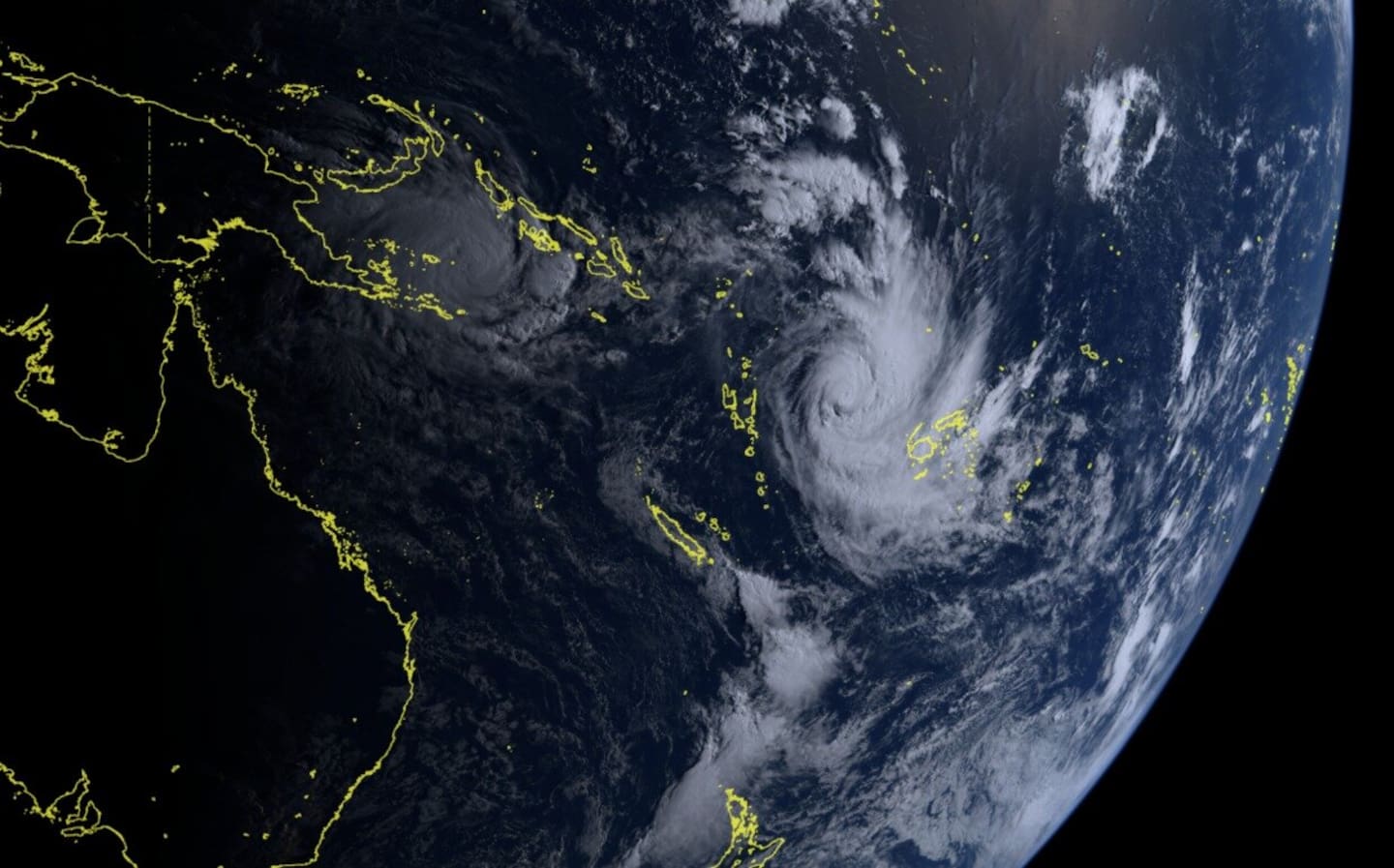
Cyclone Vaianu and Cyclone Maila. Photo / Himawari-8
Two active cyclones in Pacific
MetService says it is monitoring two tropical cyclones currently active in Pacific waters.
Spokeswoman Heather Keats told Ryan Bridge TODAY that Cyclone Vaianu, currently northwest of Fiji, is set to hit the North Island this weekend.
“As it gets upgraded, it will then drop into our neck of the woods ... it’s looking to track directly over Northland and Auckland and will have likely have quite an impact on New Zealand.”
She said Vaianu was currently a Category 2 storm but was likely to be upgraded to a Category 3 – or higher – by this afternoon.
“When it comes down over Northland and Auckland this weekend, it will hold its Category 2, which is highly unusual.”
Another cyclone, Maila, Category 3, is currently slow-moving in the Solomon Sea, which Metservice says “won’t have any bearing on New Zealand weather”.
A day of heavy rain for Northland and parts of Bay of Plenty
Metservice has upgraded a rain watch in Bay of Plenty to an orange heavy rain warning for the region west of Whakatāne, including Rotorua. 100mm to 140mm of rain is expected until midnight Wednesday.
Meanwhile, an orange heavy rain warning issued earlier for Northland has been downgraded to a rain watch. Up to 120mm of rain could fall until 6pm.
A strong wind watch is also in place for the region, where east to northeast winds could approach severe gale strength in exposed places.
Civil Defence Northland said the region has recorded 30mm to 60mm of rain so far, mainly in eastern areas, with more on its way.
“Roads and river levels remain generally stable, however, there is a lot of surface water around, especially in the east, and the ground is still quite saturated.
“Thunderstorms and localised downpours are still possible and could lead to rapidly rising rivers and streams, localised surface flooding, slips and difficult driving conditions.”

Periods of heavy rain are expected for the upper North Island and the upper South Island. Photo / MetService
There have been no reports of major incidents or power outages so far.
These warnings come after the Northland region recently suffered widespread flooding, with settlements in Whangārei and the Far North cut off and more than 80 homes damaged.
Both districts declared states of emergency following the severe weather.
Further south, a heavy rain watch has been issued for Auckland, including Aotea Great Barrier Island, with rain expected to arrive from around 9am lasting until midday tomorrow.
The watch also covers the Coromandel Peninsula from later this afternoon until 3pm tomorrow as well as Waikato, Waitomo, Taumarunui and Taupō from 3am to 8pm tomorrow.
The tail end of the weather system is expected to reach the northern South Island later today, with heavier rain forecast for Tasman, particularly northwest of Motueka from 6pm.
A MetService spokesman said most of the South Island would escape the worst of the rain, although drizzly and overcast conditions were expected along the east coast, including Canterbury.
Take your Radio, Podcasts and Music with you
Get the iHeart App
Get more of the radio, music and podcasts you love with the FREE iHeart app. Scan the QR code to download now.

Download from the app stores
Stream unlimited music, thousands of radio stations and podcasts all in one app. iHeart is easy to use and all FREE